How to Measure Earthworks in a BoQ: Cuttings and Embankments
Linear earthworks are measured by the end-area method: take the cut and fill areas at surveyed cross-sections along the chainage, integrate them between sections to get volumes, then balance what is dug against what is needed as fill. What cannot be reused is disposed; what fill cannot be met from the cut is imported. The numbers that decide the cost are not the raw cut and fill but what happens to them: how much is reused, how much goes to tip, and what shrinkage does on top. This post shows how to measure an earthworks reach under CESMM4 with a real worked example, and the place margin quietly lives.
For the wider document see a civil engineering Bill of Quantities; for the classification rules, see the step-by-step CESMM4 guide.
The end-area method
You do not measure a cutting as one lump. You take cross-sections at known chainages, each with its cut and fill areas, and integrate area along the centreline to get volume. Simpson's Rule does the integration where the sections are evenly spaced; a trapezoidal rule covers the rest. The finer the section spacing through a transition, the truer the volume. This is why an earthworks take-off is only as good as the cross-section data behind it.
The reach
The worked example is the calculator's default reach: a 100 m cutting surveyed at six cross-sections, the cut area tapering as the alignment rises, with a topsoil strip and replacement across a 20 m-wide corridor. These are the inputs, so the result is reproducible: open the calculator and it is pre-loaded with exactly this reach.
| Chainage (m) | Cut area (m²) | Topsoil strip (m²) |
|---|---|---|
| 0 | 10.0 | 20 |
| 20 | 9.0 | 20 |
| 40 | 8.0 | 20 |
| 60 | 7.5 | 20 |
| 80 | 7.0 | 20 |
| 100 | 6.0 | 20 |
Integrated by the engine's end-area method, with a 150 mm topsoil strip replaced to landscaped areas.
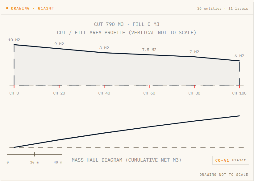
The reach as the engine draws it: the cut-area profile along the chainage, each station labelled (10 m² at CH 0 tapering to 6 m² at CH 100), with the mass-haul diagram beneath. The hash cell (81a34f) ties this to the bill below.
Measuring it under CESMM4
The bill below is real CivilQuants engine output for that reach. Treat it as a modelled example for illustration, not a tender; every number is reproducible from the section data above.
| CESMM code | Description | Quantity | Unit |
|---|---|---|---|
| D.1.1 | General site clearance | 2,000 | m² |
| E.2 | Excavation of topsoil, maximum depth not exceeding 0.25 m | 300 | m³ |
| E.4.2.4 | General excavation, maximum depth 1 to 2 m | 790 | m³ |
| E.5.3 | Disposal of excavated material off-site | 790 | m³ |
| E.6.1 | Filling, site-won topsoil, 150 mm, to landscaped areas | 300 | m³ |
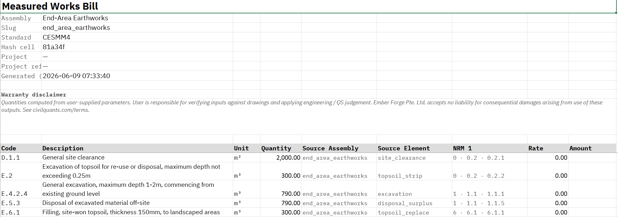
The full CESMM4 bill: clearance in Class D, the topsoil and general earthworks in Class E. Every quantity traces to the cross-section data.
This reach is a pure cutting: there is no embankment in it to receive the spoil, so all 790 m³ of general cut is surplus and goes to tip. Only the topsoil is reused, 300 m³ stripped and 300 m³ replaced as landscaping. The whole corridor is cleared first (2,000 m²).
Cut, fill and shrinkage
What you see here, all the cut disposed, is one end of a spectrum. The moment the alignment builds an embankment, that same cut feeds the fill instead of the tip, and two adjustments decide the expensive lines:
- Shrinkage. Placed and compacted fill occupies less volume than the cut it came from (typically a 0.90 factor from SHW Series 600). You need more cut to make a given embankment than its neat volume suggests, so a reach that looks balanced on paper can still leave surplus to tip, or fall short and need import.
- Bulking. Excavated material occupies more volume loose than in the ground, so the haulage volume is larger than the in-situ dig. Price the haul on the loose volume, not the neat cut.
Get these wrong and the disposal and import quantities, the expensive ones, come out wrong. The CivilQuants engine applies the SHW Series 600 factors and shows them in the assumptions, so the 790 m³ of disposal is traceable to the cut, the fill requirement and the factors, not a round guess.
Disposal versus reuse
The single most valuable decision on an earthworks bill is how much of the cut is acceptable for reuse. In this pure cutting there is nowhere to reuse the general cut, so it is all surplus, but on a real alignment the split between embankment fill and disposal is where the money is. Where a proportion of the cut is unacceptable (soft, contaminated, wrong class), it must go to tip and be replaced with imported fill, which is two expensive lines instead of a free one. Measuring the disposal-versus-reuse split honestly, and stating the acceptability assumption, is what keeps the bill defensible. The pavement that sits on the formed subgrade is measured separately; see carriageway pavement layers, and any retaining structures as retaining walls.
Common errors
- Ignoring shrinkage and bulking. The neat cut and fill are not the haul, disposal and import volumes. Apply the factors.
- Assuming all cut is reusable. Unacceptable material means disposal plus import, two costly lines.
- Too-coarse cross-sections. Volumes through a transition need close section spacing to be true.
- Forgetting topsoil and clearance. Strip, replacement and site clearance are separate measured items.
Try it
Measure an earthworks reach from your cross-section data and read the cut-and-fill balance. Start a 7-day pass for £15, or try a free assembly to MMHW with no sign-up, then open the earthworks calculator.
Frequently asked questions
- How are earthworks measured in a Bill of Quantities?
- By the end-area method: cut and fill areas at surveyed cross-sections, integrated along the chainage to volumes, then balanced into reuse, disposal and import, with topsoil and clearance measured separately.
- What is the end-area method?
- A way of getting earthwork volumes by integrating cross-sectional areas along the centreline, usually with Simpson's Rule, between surveyed sections.
- What are bulking and shrinkage?
- Bulking is the increase in volume of excavated material when loosened (it affects haulage); shrinkage is the reduction in volume of fill when compacted (it affects how much cut a given embankment needs). Both come from SHW Series 600.
- How do you balance cut and fill?
- Compare the cut available against the fill required, after shrinkage. Surplus acceptable cut is disposed; any fill shortfall is imported.
- Why does some excavated material have to be disposed of?
- Either it is surplus to the fill requirement, or it is unacceptable for reuse (soft, contaminated, wrong class) and must be tipped and replaced with imported fill.
- Which CESMM4 classes do earthworks use?
- Class D for site clearance and Class E for topsoil, excavation, disposal and filling.